Tour de Blast 2008 - Mt. St. Helens

Such a peaceful scene of Mt St Helens, it's difficult to think it was so devistating.

Here we are after awaking at 3:15 am...getting ready and driving 2 1/2 hours, Jeff, Tyler and me(Doug) behind camera, leaving Toutle High School. We have to sign in and get moving. It's 6:30 am.

Shortly after leaving at about mile 12, Jeffs bike breaks a spoke. This is not good as the wheel continues to groan.

Here we are at the first rest area. The Longview Rotary Club has things running smoothly at these rest stops. There are various energy bars and fruits as well as water and power drink available. Of course sani-cans are available too.

Shortly after photo Jeff (that's him ahead of me) had to bail out. His wheel got cranky and repairs not eminent. With the larger grades ahead and for safety he returned for a successful ride in the future. He told us to go on!! This one's for Jeff!

This awesome bridge was built by the federal government after the 1980 Mt St Helens blast blew away the roads and bridges in the area. This is the Hoffstadt Creek bridge some 370 feet above the creek. I love this photo with no cars on the roadway. The viewpoint was easy to get to though bikers too busy riding to stop...except for me.

Tyler impressed numerous folks with his original biker gear. I called it the beach bum look. Everyone in spandex looked boring so this original style was refreshing. There is a roadway above and beyond Tyler which is where we are heading and it is some 300 feet higher and about 1/2 a mile around a horsehoe curve to get to. We found this to be the theme during the ride....and guess what's around that corner???yes, another climb!

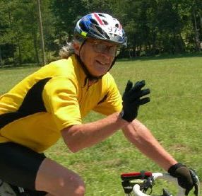
Here I am taking a photo in my camera phone even though there is no coverage. That's some wild hair, blown by with wind up there which was very strong at 45 mph! The ride was almost canceled up at the top because of the winds. In front of me but 5 miles distant is the blast area of Mt St Helens. That was quite the blast May 18,1980! Sandra and I were in Prosser and heard it blow! That's over 100 miles away! We were stuck there for two days with ash blocking our exit northward and rivers filled with debris blocking the west side.

This is a long chunk of snow guiding us to the bikers rest area at the top.

Wind and snow would be the words for the top of the climb. We arrived at Johnstone Ridge view point 4 hrs 44 min after we left. It took us 2 hr 40 min to return. 42 miles up, 42 down, total...84 miles.

Tyler strikes his victory pose!! He has made it!!!

This is a beautiful shot of the mountain, enjoy.

Unfortunately the downhill and its speed end in a crash at times. This is a shot of a crash scene. The biker was airlifted out after his crash on the downhill curve and apparent side gusting wind. All traffic was halted until the scene was cleared.
Here's a little bit of video...
A couple of facts, the ride started at 500 ft elevation, and had a maximum elevation of 4200 ft. The ups and downs made the ride a cumulative 8000 ft. elevation gain. Not the greatest, but plenty for one day.

For an after ride dinner, we stopped in Centralia (a fantastic little town..get over to Main Street - Classic Americana) and ate at Gibsons !!! It is awesome! Great food and Great service.
Labels: Mt. St. Helens, Tour de Blast 2008
posted by "On Your Left!" @ 7:24 AM
2 comments
![]()